Many of readers of this blog are outdoor enthusiasts. One “game” that has gained in popularity among outdoor enthusiasts is Geocaching. Geocaching is basically a high-tech treasure hunt where people get coordinates for a hidden geocache from a website called geocaching.com. They then enter those coordinates into a GPS receiver, or into their GPS-enabled smart phone (with an App) before going to search for the geocache out in the woods. Geocaching.com’s Geocaching 101 page has a lot of great information about the hobby, as does this video:
This coming Sunday, October 14 is International EarthCache Day. EarthCaches are a special type of geocaches where instead of a traditional cache there is some sort of earth science education lesson for the geocache hunter. It’s been a while since I’ve been out geocaching (being a graduate student takes a lot of time). However, I have a blast every time I go geocaching. As wetland and soil scientist, earth caches are always extra fun because I get to learn (or be reminded) about some awesome scientific fact! Many of these EarthCaches highlight a unique geological feature of a particular location.
If you go geocaching on Sunday looking for an EarthCache, and you find one that teaches you about soil, or any other interesting earth science fact, please come back to this blog post and tell everyone about it in the comments section!
I came across a news article put out by the BBC. It was entitled Earthworm Invasion: Aliens Causing More Harm Than Good? by Jeremy Coles and Matt Walker. It is an interesting article, and an interesting soil science topic. I recommend going and reading that article first, then come on back to ColbyDigsSoil to read the rest of this article.
Photo credit: BBC
Earthworms are organisms that live in the soil. They consume soil that is high in organic matter (organic matter is basically decayed plant material such as fallen leaves, grass clippings, dead roots, etc.). As the worms consume the soil, their digestive systems break down the soil organic matter and converts it into energy for the worm. The worm excrement, called “castings”, is usually also high in organic matter, and it has an excellent soil structure that is similar to granular structure.
The food that we humans consume is different, nutrient and composition-wise, than the waste we create. Likewise, the worm food (soil) is different than the waste they create. This is where worms can become useful, or become a problem. If they change the nutrient dynamics (how nutrients like nitrogen cycle through the environment) too drastically, it could cause problems, or even change the ecosystem all together. Changes caused by the invasion of a non-native worm species could include altering the amount of leaf litter on the forest floor, the out-competing of native worms by the invasive worms, increasing or decreasing the availability of nutrients to plants and microbes, and even altering the physical properties of soils like how fast water can move through the soil (generally, the faster, the better).
All-in-all, it’s an interesting ecological problem.
What are your thoughts on “alien worms”? Do you have any worm stories you’d like to share? Please do so in the comments section of this blog post.
I’m sure many of you are very familiar with the extensive number of social network sites available these days. The most popular is, of course Facebook. This is followed closely by Twitter (you can follow me, by the way, at https://twitter.com/ColbyDigsSoil). One more that is on the rise is Google+, which has quickly became one of my favorite social network sites because it makes Science so accessible. To get an idea for what Google+ is, check out this video:
I started using Google+ about a year ago (you can circle me here). Facebook was starting to get boring to me and I was looking for something similar, but different. I had my Google+ profile up and running for a few months. I was impressed by how well it worked, both in regards to privacy and just overall function, but I was sort of disappointed by the lack of new material that showed up on my news feed each day (a product of not having many friends on the site yet, due to already having a Facebook account). I was even considering giving up on it… that is, until I found the Science on Google+ database. That is when I realized what it’s potential could be, and that I was “doing it wrong” by using Google+ as a Facebook “analog”.
You see, Google+ lives up to its potential when it’s used as a hybrid social networking site, RSS feed, and a news aggregater (think Facebook/Twitter, RSS Reader, and Google News all in one). Take that, and organize it in a way where the user can separate specific topics (like science) from everything else, and you have a winning combination!
Google (founded by graduate student scientists) works hard to support science. As a means to do so, Google developed a “science database” through which scientists and science teachers of similar or different disciplines can collaborate, brainstorm, share, or even chat (in Google+ hangouts) about their science.
To read in more detail about how the database works, please read the “About” page on the Google+ Science Database. There, it discusses how it works, and also lists more specific circles within the database you can follow according to your interests. Some that may be interesting to readers of Colby Digs Soil include:
I’ve found a lot of interesting articles and incredible photography through this database. It has really increased my enjoyment of using Google+. I also added myself to the Geology and Earth Science database. When I have a soil science-related blog post here on Colby Digs Soil, I’ll share it with that circle and it will go out to the feeds of the rest of the followers of that circle. In doing so, I have also had the pleasure of interacting with scientists from all over the world who I would never had heard of otherwise. By the way, if you circle me on Google+, please let me know you are one of my readers, or at least put your career in interests information into your bio so I can add you back. I’ll do my best to follow people with similar interests.
Some people and pages I recommend on Google+ to the Colby Digs Soil readers include:
Note: I’ll come back to this post and edit that list as I find more people/pages to follow. If you have a suggestion, please post it in the comments!
I don’t want to sound like a Google “fan boy” (even though I probably am) but if you still need convincing in order to try Google+, the Google+ app is pretty awesome. Also syncing pictures from an Android phone to Google+/Picasa is seamless.
As some of you may know, I am a homebrewer, along with several other faculty, staff, and students in the NCSU Dept. of Soil Science. Last week I was offered the opportunity to pick hops on a hops variety trial that our department has been working on for the last few years along with the horticulture department. I was told that I could keep whatever I picked. A homebrewer on a grad student budget doesn’t pass up an opportunity like that!
Hops are a bittering agent used in beer. Bittering agents, along with the presence of alcohol, act as natural preservatives that keep bad microbes from growing in beer. Charlie Papazian, a well known author of homebrewing books, posted an article on his blog recently about hops that gives a good perspective on how homebrewers and brewers relish hops.
In the US, most of the hops are grown in the Pacific Northwest (Washington, Oregon, Northern California, etc.). This region has long days during the growing season, and perfect climatic conditions for hops. The areas were hops are grown in this region also have very low humidity. North Carolina, on the other hand, has high humidity and shorter days during the growing season. The humidity makes the hop plants susceptible to disease. The point of this trial was to identify what varieties might be worth growing in the state on a commercial scale to supply the growing craft brewery demand for hops in the state. You can read about the project, results, etc. on the research group’s website.
I think this project is a good example of how investments in science can help develop new markets. It’s still unknown, and probably unlikely, that a booming hop industry will develop in North Carolina. But I think there will always be a small market for niche farmers hoping to provide local hops to “locavore” homebrewers, and perhaps some craft breweries for special batches of brew.
Here are some pictures of the hand-harvesting process for the hop yard trial:
This is the hop yard. The trellaces are 14 ft tall. The ladder shown in the picture is 8 ft tall for reference. The total area is 1/4 acre.Picking hops
For each plant we harvested, we had to weigh the wet weight yield. We spent about three hours harvesting that morning. Once we were done harvesting and weighing the yield we took the hops back to campus to dry them.
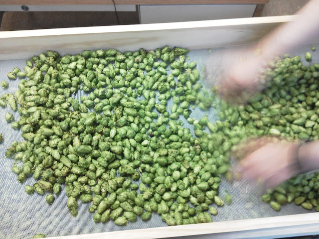
We spread out the hops on a rack of trays. Each tray has a screen for the bottom. Some box fans are set up below all the racks. Those fans pull air through the trays and hops, and blows the air out the sides of the stack near the bottom. It takes about two days to dry them. As we laid out the hops, we had to pick out the bad ones too.
Drying hopsPicking out the bad hopsA full stack of six hop trays
Our total harvest for two guys picking hops by hand was 21.5 oz in three hours. We had 10 oz of Cascade, 3 oz of Newport, 5 oz of Nugget, and 3.5 oz of Zeus. I didn’t get a picture of it, but once the hops were dried, we packaged them using a vacuum-pack machine. They are then stored in a freezer until they’re ready for brewing.
It was a fun project to help with, and made for a nice change of pace from my own research.
Mars Science Laboratory, aka Curiosity Rover. Photo courtesy of NASA
You may have heard about the successful landing of NASA’s Curiosity Rover on Mars this morning. The Curiosity Rover, also known as the “Mars Science Laboratory” (MSL) is the latest of several unmanned missions to the red planet to study its formation, and the possibility that it could, or previously has supported life.
The landing of the rover on the planet was an amazing feat of engineering in itself. Here’s a video that shows just that:
And here’s NASA’s image of the day that shows one of the first photos of the red planet taken by the rover:
One of the first photos of the red planet taken by the Curiosity Rover. Photo courtesy of NASA.
Tonight, on the planet Mars, the United States of America made history.
The successful landing of Curiosity – the most sophisticated roving laboratory ever to land on another planet – marks an unprecedented feat of technology that will stand as a point of national pride far into the future. It proves that even the longest of odds are no match for our unique blend of ingenuity and determination.
Tonight’s success, delivered by NASA, parallels our major steps forward towards a vision for a new partnership with American companies to send American astronauts into space on American spacecraft. That partnership will save taxpayer dollars while allowing NASA to do what it has always done best – push the very boundaries of human knowledge. And tonight’s success reminds us that our preeminence – not just in space, but here on Earth – depends on continuing to invest wisely in the innovation, technology, and basic research that has always made our economy the envy of the world.
I congratulate and thank all the men and women of NASA who made this remarkable accomplishment a reality – and I eagerly await what Curiosity has yet to discover.
Congratulations to the whole MSL team on that great achievement.
However, for soil scientists like me the interesting part is just getting started. The mission of the MSL is to study minerals in the Martian “soil” and on the outside of rocks on the surface. The rover’s targeted (and achieved) landing spot is in Gale Crater, which from my understanding, is one of the most likely spots to observe minerals that formed in water (being that it is on a low spot on the surface of the planet… and water flows downhill).
The yellow oval marks the target landing spot for Curiosity in Gale Crater. Photo courtesy of NASA.
The instruments on the MSL are pretty much the same instruments used by soil scientists and geologists here on Earth, only lighter, smaller, mission-specific, and a lot more expensive!
NASA scientist working with the MSL “arm” and instruments. Photo courtesy of NASAScientific Instruments on the MSL. Photo Courtesy of NASA
Measurements taken with these instruments will help geologists and soil scientists identify the minerals present in Gale Crater. Previously-established knowledge of the minerals they find will help determine if there was or is water present on the surface of Mars.
Some instrumentation on the MSL is designed to detect organic molecules – the building blocks of life. From what I understand, the MSL is not set up to “detect life”, but only to see if what is necessary for it to be formed is present on Mars, i.e. water, organic compounds, and climate.
Doug Ming, PhD. Photo courtesy of NASA
I’ve followed the Mars rover missions pretty closely since they started. I gained an even greater interest in them when I heard a talk by Doug Ming, PhD (right) at a Soil and Water Conservation Society meeting in Tucson, AZ. His title is the “Science Operations Working Group Chair” which means he puts together the activities they do on Mars for a given sol (Martian day). At the NCSU Dept. of Soil Science we were lucky enough to host Dr. Ming as our Willie Woltz Lecture Series speaker in 2009 towards the end of the Phoenix mission. It was fascinating to hear about the results of those missions and what kind of mineralogy they’re finding. You could say that Doug Ming, and his team of scientists do soil science that is “out of this world!”
I’m definitely intrigued by this series of missions, and I will post occasionally about them here at ColbyDigsSoil. If you would like to follow the Curiosity Rover here are a few great sources about the mission and how to stay informed:
Today’s post will focus on soil structure. Previously, soil texture was defined as the relative proportion of soil particles (sand, silt, and clay). Soil structure is the arrangement of those soil particles into aggregates, or peds. Soil structure is important because it has a direct impact on many soil physical properties, but especially on the rate at which water flows through the soil. This impacts water availability for crops, site suitability for various buildings and septic systems, and more.
Soil scientists describe soil structure based on three things – type, size, and grade.
Structure Type
The structure type is simply the shape of the chunks of soil, referred to as “peds”. The different types are shown here:
Photo courtesy of the University of Hawaii at Manoa
Granularsoil structure is roughly spherical in shape. It is similar to the shape of granola and/or Grape Nuts (the cereal). Both start with “g-r-a-n”, so think of those two foods when you think of granular. This type of structure is common where there is a high amount of organic matter present – often in the A horizon, or surface horizon of the soil. It allows for a fast infiltration rate (the rate at which rain water can enter the soil profile), thus maintaining organic matter in your soil profile can benefit your garden/crop by allowing more rainwater to enter the soil profile.
Granular Soil Structure. Photo courtesy of the NCSU Soil Science Flickr Photo Stream.
Blockysoil structure is shaped just as it sounds – like little blocks. The blocks are nearly the same size in all dimensions. Blocky structure is most common in the B horizon where clay content is higher. It can also occur in Histosol soils that have been drained. There are two types of block structure – angular, and subangular. Angular has sharp edges, while subangular has more dull edges. The type of block structure depends on the clay minerology, and the amount of shrink-swell clay (more on that in a future blog post). Shrink swell clay can expand upon wetting, thus causing slow movement of water. Good subangular blocky structure can have very rapid movement of water.
Subangular Blocky Soil Structure. Photo Courtesy of the NCSU Soil Science Flickr StreamAngulary Blocky Soil Structure. Photo by John Kelly via the NCSU Soil Science Flickr stream.
Prismatic soil structure is similar to blocky, except that the blocks are more tall than they are wide. Prismatic structure usually occurs in the B horizon. It is common to have prismatic structure that breaks into smaller, blocky structure when the prismatic ped is handled. This is called “compound structure”, meaning there is one structure type within another.
Prismatic Soil Structure. Photo courtesy of the NCSU Soil Science Flickr stream
Columnar soil structure looks very similar to prismatic structure, except columnar has a rounded top. This structure occurs in arid climates where there is a higher concentration of salts in the soil.
Columnar structure. Photo courtesy of the USDA NRCS
Platy soil structure consists of soil peds that are wider than they are tall. It often occurs in compacted soil. Platy structure causes slower movement of water down through the profile. If it formed due to compaction, root growth through that soil layer will also be hindered.
Platy Soil Structure. Photo by David Lindbo via the NCSU Soil Science Flickr stream.
Wedge soil structure is a shape similar to that of a football (North American). It occurs in soils that have a high amount of shrink-swell clays like in the Vertisol soil order (Soil Taxonomy). As the peds wet and dry, the peds slide over each other elongating the peds into a wedge-like shape. Where ped faces slide over each other, slickensides (smooth films of clay) line the outside of the peds.
Wedge Soil Structure. Photo courtesy of David Lindbo.
Structureless – single grained soil structure means that there is no structure, only individual soil particles (sand) that are not aggregated into any other soil structure. Beach sand is a good example.
Structureless-Single Grained. Photo courtesy of David Lindbo.
Structureless – massive soil structure means, again, that there is no structure. The soil does not easily break along plains of weakness because there are none. This is common in C horizons where it is only parent material and no (or little) soil development has occurred.
Structureless-Massive. Photo courtesy of David Lindbo.
Structureless – massive, rock controlled fabric (a term used by the NCSU soil science folks, but not commonly used by others) occurs in saprolite (rotten, weathered rock) where the soil does have structure. However, that structure is not due to soil forming processes, but is due to the inherited structure of the parent material (what was once a rock).
Structureless-Rock Controlled Fabric. Photo courtesy of David Lindbo.
Structure Size
In addition to structure type, structure is also described by soil scientists based on ped size, and structure strength. Ped size is simply the average size of peds within different size categories. The picture below shows the use of the USDA’s Field Book for Describing and Sampling Soils to determine the ped size for angular and subangular blocky structure. The sizes are grouped into different ranges of diameter, such as fine, medium, coarse, etc. The range “descriptor” may change as well, such as thick, medium, and thin for platy structure.
Determining soil structure size. Photo courtesy of the NCSU Soil Science Flickr stream.
Structure Grade
The final characteristic used to describe soil structure is Grade. Numbers and words (associated with strength) are used to describe grade. The numbers 0 through 3 are used for grade. A grade of 0 indicates that no soil structure is present (ie, the soil is massive). A grade of 1 indicates weak soil structure, 2 indicates medium structure. Lastly, 3 indicates strong structure. Strong structure can easily be seen in a soil pit, as the soil peds will have large gaps in-between the peds. Weak soil structure will not be easily seen in a soil pit, but peds may break into a discernible shape when they are manipulated or squeezed. Medium is somewhere in-between strong and weak.
Strong Soil Structure. The soil profile shown here depicts a strong soil structure where very visible macropores (gaps) between the prismatic soil structure can be seen from a distance. Photo courtesy of the NCSU Soil Science Flickr stream.
Implications and Summary
As I stated in the beginning, soil structure is very important for a variety of reasons. Most of those reasons boil down to how fast water can flow through the soil, and how easily plant roots can penetrate the soil. The stronger the structure, the faster water and roots can penetrate the soil. A diagram from Colorado State University (below) does a great job of sumarizing how structure can affect water flow:
Infiltration rates through different soil structure. Diagram courtesy of Colorado State University
Soil structure is created through pedogenic (soil forming) processes over long periods of time, but can be destroyed quickly through compaction. In your field, garden, or yard, you can encourage good soil structure by limiting traffic on the soil, avoiding tillage when the soil is wet (when it has the least strength), and adding organic matter either manually, or through agricultural practices.
Soil structure is a topic that usually takes several lectures to cover in college-level soils courses, so we won’t be able to cover all of it in one blog post here. However this post should give you a thorough understanding about how structure is described, and some potential impacts of soil structure.
One of the most important characteristics of soils is soil texture. Soil, by definition, consists of particles less than 2 mm in diameter. Soil texture is the proportion of sand, silt, and clay particles that are of soil size (2 mm or less). The US Department of Agriculture classifies soil particle sizes as the following: sand particles are the largest soil particles and range from 0.05 mm to 2.00 mm in diameter, clay particles are the smallest and are less than 0.002 mm in diameter, and silt-sized particles are in the middle. The Disovery Channel website actually has a good graphic to demonstrate the relative size of each particle size class:
Relative Soil Particle Sizes. Source: The Disovery Channel
Since gravel is larger than 2 mm in diameter, it is not considered a soil particle. Another good visual description is to consider a beach ball as a sand particle, a silt particle as a baseball, and a clay particle as a BB. That would be roughly the relative sizes of each particle if they were enlarged.
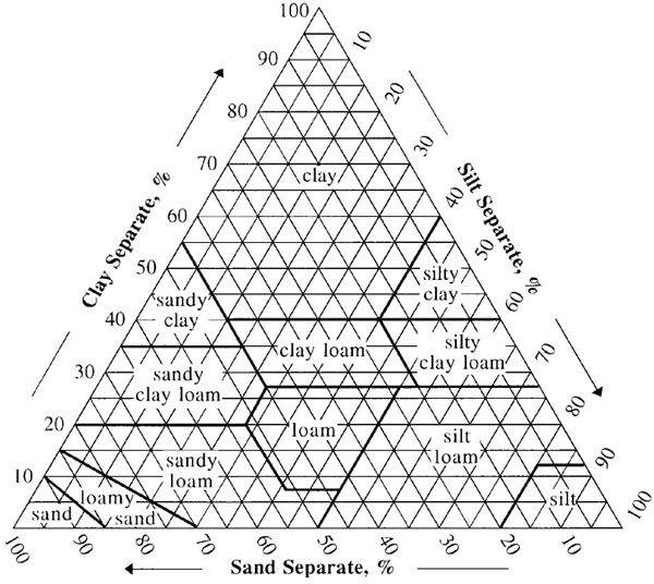
Soil scientists classify soil textures into 12 soil texture classes as shown in the soil texture triangle:
Soil Textural Triangle. Source: USDA NRCS
As an example, say we have a soil that is 45% clay. So we move up the left side of the Triangle until we get to the 45% line (numbers align with their respective lines). This soil is also 30% sand so we move from the right side to the left along the bottom axis until we get to the 30% sand line. The point where the 45% clay and the 30% sand lines intersect lies within the boundaries of the clay loam soil texture class. We can follow the silt percentage line to find that we have 25% silt. Since the sum of each should add to 100% we can also find the silt proportion by difference (100% – 45% – 30% = 25%).
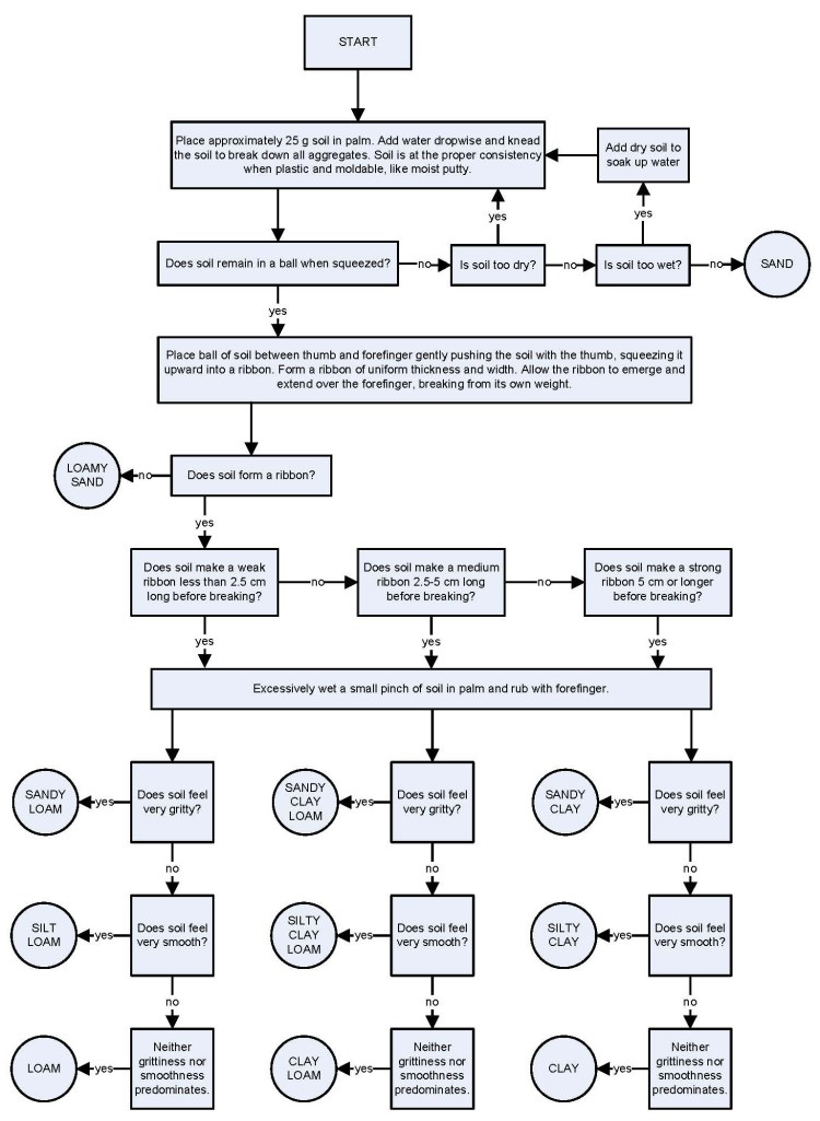
Soil scientists measure soil texture by a variety of methods. The most common for everyday use is the texture-by-feel method which can be done using the following chart (click to enlarge):
Texture-by-Feel Flowchart. Source: USDA NRCS
It is just like any other dichotomous key with a series of yes/no questions. It doesn’t really give an exact percentage of the sand, silt, and clay, but gets the scientist “in the ballpark” of what the soil texture class should be. UC Davis put out a great video on how to do texture by feel:
Texture by feel is useful in the field. It does take lots of practice to “calibrate” your hands with soils of known textures. Some tips that I’ve learned along the way are the following:
Mica in the sand-sized fraction can act like clay making long ribbons
Silt feels like baking flour
Expansive clays may lead longer ribbons and overestimation of clay content
Another method that is commonly used is the hydrometer method, which is a more reliable, repeatable, and unbiased method than texture by feel, thought it takes much longer. The Natural Resources Conservation Service (NRCS) made a great video on how to determine soil texture by the hydrometer method:
The chemical they use is a dispersant which chemically breaks up any soil peds or aggregates.
Soil texture is more than just how the soil feels to you or me. Soil texture is important because it is one of the principle properties of soils. Texture effects on how fast water can move through soil, erodability, retention of nutrients for plants and microbes, the microbiol community makeup, bulk density, and with all of those properties, what ecosystems or cropping systems can exist on that soil.
Since soil texture is so important, I’ll be referring back to this post regularly in future blog posts.
At the beginning of this week I helped some faculty in the NCSU Dept. of Soil Science with the North Carolina Geomorphology Tour. The tour is a one-week field class that starts at the outer banks of North Carolina and ends in the mountains at the Tennessee boarder. Along the way the students examine and classify soils of all different types while the professors provide some interpretation and lead discussion on what conditions caused each soil to form.
At each of the sites where we stopped, all of the students broke out into six groups and worked to describe and classify the soil at their assigned location. My job was to bounce around from group to group to answer any questions and help walk them through the Keys to Soil Taxonomy as they classified their soil. I also helped a little with the discussion at each stop.
Here are some pictures I took along the way…
The Wright Brothers Memorial
Our first stop on the trip was to the Wright Brothers Memorial at Kitty Hawk, NC. This memorial commemorates the first ever self powered flight. It’s also located on a huge dune that overlooks all of the development in the area. There were several soil science concepts we covered here, including the form of the large wind-blown dunes on the outer banks, desication of plants (trees especially) due to the wind and salt and how that affects what plants can grow in this environment, the availability of drinking water on the outer banks, and how growth was limited on Kitty Hawk and Nags Head by the city not developing a public sewage system (the property owners can only build a house as big as their septic system can handle… thus no 8 story condos).
The Wright Brothers Memorial Dune
We then moved on to the beach. The North Carolina Outer Banks are a system of islands that move seaward or landward depending on sea level (on a geologic time scale). Currently the islands are moving landward with ocean level rising since the last ice age. However, that doesn’t stop people from developing the outer banks with multi-million dollar homes that are rented to tourists. These houses are annually at risk of being washed into the ocean.
A house that almost fell into the drink is now protected by “beach renourishment”. Would you buy a house here?
However, through successful lobbying, the State of North Carolina and the federal government have stepped in to pay for “beach renourishment, which is the act of dredging sand from 2 or 3 miles off the coast, and blowing it back on to the beach. This in turn protects the houses for as long as the sand lasts. It is constantly being eroded, so it will take another huge influx of taxpayer money in a few years to protect these million dollar homes.
The Soil Geomorphology class looks on as the “beach renourishment” sand erodes back into the ocean.
As a soil scientist, I think that it is unwise for the government to pay to protect million dollar houses, or any houses for that matter, on land that will inevitably be eroded away by beach erosion some day, nor should it fund the construction of cities in annually flooded areas. I think it’s more logical to let nature run its course most of the time and not build permanent structures on non-permanent landscapes.
The “beach renourishment” added about 200 meter wide strip of sand to this beach. Beforehand the beach was literally underneath the stilts of the houses.
That was it for the first day. Most of the first day had been taken up by the 4 hour trip from Raleigh to the outer banks.
On the second day we first stopped at Nags Head Woods to look at soils in a Maritime Forest. We then went to Manteo to look at a variety of Spodosols (an order of soils that develop in sandy areas under pine forests, pictured below).
Spodosols at Manteo, NC
After that we went on to the mainland where we stopped at Somerset Place on the shore of Phelps Lake, which was once one of the biggest plantations in the state of North Carolina with an area of 100,000 acres. Somerset place had over 800 slaves, cumulatively, and a peak area under production of around 8,000 acres. They grew rice, corn, wheat, and more. They also planted some amazing bald cypress trees as you can see with my picture below. By the way, bald cypress are the species I research for my graduate work.
Colby standing next to a bald cypress tree (Taxodium distichum) at Somerset Place.
We did one more stop on the shore of Phelps Lake. Phelps Lake is a pocosin lake. Pocosins are swamps that form on lands that are very wide (on the order of many miles), and very flat (as in flat as a pancake) where the source of water is rainfall, and the water cannot drain fast enough so it only leaves via transpiration. Over time these wet conditions allow for the accumulation of plant matter to create Histosols. The swamp that forms is actually the highest point on the landscape, thus bringing us to the term “pocosin” which is Algonquin Indian for “swamp on a hill”. When lakes form on these pocosins, they are termed pocosin lakes. These are the only naturally occurring lakes in the state of North Carolina.
Dr. Lindbo explaining how pocosins and pocosin lakes form.Cypress trees growing on the organic soil shore of Lake Phelps
We dug some profiles in the Histosols around the edge of the lake so that everyone there could see and feel organic sols.
Histosols near the edge of Lake Phelps
Our last stop was to look at some lower coastal plain Ultisols at the Vernon James Tidewater Research Center (an extension and research farm for NCSU).
Vernon James Center Ultisols
After that Alan Meijer, a PhD student and extension agent for the NCSU Dept. of Soil Science gave us a tour of the different tillage, planting, and harvesting equipment used on the research farm.
Alan Meijer presenting tillage equipment
We ended the long day with pizza and a presentation from Paul Lily, Soil Science Professor Emeritus, on the history of North Carolina with a soils and agriculture perspective.
On the third day (and last day for me, I had to get back to Raleigh to do real work) we made our way up the coastal plain and back to Raleigh. The coastal plain is an area along the Atlantic coast of the US that consists of marine, and alluvial sediments (sediments deposited by the ocean and by rivers). The oldest parts of it are at about 300 feet elevation, the youngest parts are at the beach. We stopped to look at some scarps (abandoned beaches from times of higher ocean levels), some flood plains, and some toposequences (we examined soils along a hillslope to see how topography affected the soils).
Some Tupelo Gum trees in the backswamp of the Tar River floodplainSoil profiles along a toposequence in the Coastal Plain.A gully that was down-cut since settlement of North America has exposed a nice soil profile of a Grossarenic Hapludult.
That’s pretty much it for the leg of the trip in which I participated. I did do the full trip as a student the last time the course was offered (in 2010). If you would like to read about that adventure you can read about it on my personal blog here. All of the pictures from this trip are available on my Soil Geomorphology Tour 2012 Picasa Album. Pictures from the entire week’s trip from 2010 are available on my Soil Geomorphology Tour 2010 Picasa Album.
This is just a quick post for today. June 29 through May 6 is Soil and Water Stewardship Week, as declared by the governors of Iowa (my home state) and Oklahoma in their respective states. The Conservation Blogger (the blog brought to you by the Soil and Water Conservation Society) had a great post on the story with some equally good links, so I will just send you there for “the scoop”: National Soil and Water Stewardship Week.
I encourage you to take a few minutes this week to contemplate just what soil and water stewardship means to you, and perhaps what you can do to do more.
When I’m not trudging around in a swamp, mixing up chemicals in a lab, writing something on a computer, or partaking in one of my many hobbies, I enjoy my fair share of TV. Last night I was staying up later than I should and was watching The Late Show with David Letterman. His guest was Governor of Montana Brian Schweitzer who seems to be on some tourism promotion tour in the New York area for Montana. You might ask: “what does this have to do with soil science?” Well, in the video of the interview below towards the beginning, Gov. Schweitzer talks about his education and receiving a BS in International Agronomy from Colorado State University, and an MS in Soil Science from Montana State University. He then went on to talk about some international projects that he worked on following his education, including an irrigation project in Libya, building the world’s largest dairy farm in Saudi Arabia, and how the Saudis went from a food importer, to a food exporter over the course of 7 years.
I am not able to imbed the video directly on this page, but the following tweet was sent out by the governor with the link to the Youtube video:
For those soil scientists and agronomists out their, I’d definitely recommend listening to at least the first 3 minutes of the interview. It’s great to hear what we do be discussed on a TV show with millions of viewers.
Gov. Brian Schweitzer, Photo: Wikipedia
I don’t plan to ever become political in this blog (except in the defense of science and science funding when needed), but I was impressed with the governor… but again I might be biased being that he is a soil scientist after all.
 Many of readers of this blog are outdoor enthusiasts. One “game” that has gained in popularity among outdoor enthusiasts is Geocaching. Geocaching is basically a high-tech treasure hunt where people get coordinates for a hidden geocache from a website called geocaching.com. They then enter those coordinates into a GPS receiver, or into their GPS-enabled smart phone (with an App) before going to search for the geocache out in the woods. Geocaching.com’s Geocaching 101 page has a lot of great information about the hobby, as does this video:
 This coming Sunday, October 14 is International EarthCache Day. EarthCaches are a special type of geocaches where instead of a traditional cache there is some sort of earth science education lesson for the geocache hunter. It’s been a while since I’ve been out geocaching (being a graduate student takes a lot of time). However, I have a blast every time I go geocaching. As wetland and soil scientist, earth caches are always extra fun because I get to learn (or be reminded) about some awesome scientific fact! Many of these EarthCaches highlight a unique geological feature of a particular location.
 Google (founded by graduate student scientists) works hard to support science. As a means to do so, Google developed a “science database” through which scientists and science teachers of similar or different disciplines can collaborate, brainstorm, share, or even chat (in Google+ hangouts) about their science.


 When I’m not trudging around in a swamp, mixing up chemicals in a lab, writing something on a computer, or partaking in one of my many hobbies, I enjoy my fair share of TV. Last night I was staying up later than I should and was watching The Late Show with David Letterman. His guest was Governor of Montana Brian Schweitzer who seems to be on some tourism promotion tour in the New York area for Montana. You might ask: “what does this have to do with soil science?” Well, in the video of the interview below towards the beginning, Gov. Schweitzer talks about his education and receiving a BS in International Agronomy from Colorado State University, and an MS in Soil Science from Montana State University. He then went on to talk about some international projects that he worked on following his education, including an irrigation project in Libya, building the world’s largest dairy farm in Saudi Arabia, and how the Saudis went from a food importer, to a food exporter over the course of 7 years.
